


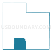
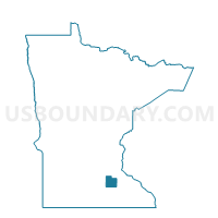
Warsaw Twp. Voting District, Rice County, Minnesota
About
Outline

Summary
| Unique Area Identifier | 604073 |
| Name | Warsaw Twp. Voting District |
| County | Rice County |
| State | Minnesota |
| Area (square miles) | 35.01 |
| Land Area (square miles) | 32.37 |
| Water Area (square miles) | 2.63 |
| % of Land Area | 92.48 |
| % of Water Area | 7.52 |
| Latitude of the Internal Point | 44.23743950 |
| Longtitude of the Internal Point | -93.34549960 |
Maps

Graphs
Select a template below for downloading or customizing gragh for Warsaw Twp. Voting District, Rice County, Minnesota


Neighbors
Neighoring Voting District (by Name) Neighboring Voting District on the Map
- Deerfield Twp. Voting District, Steele County, MN
- Faribault P-3, Rice County, MN
- Faribault P-4, Rice County, MN
- Faribault P-5, Rice County, MN
- Medford Twp. Voting District, Steele County, MN
- Morristown Twp. Voting District, Rice County, MN
- Shieldsville Twp. Voting District, Rice County, MN
- Walcott Twp. Voting District, Rice County, MN
- Wells Twp. Voting District, Rice County, MN
Top 10 Neighboring County Subdivision (by Population) Neighboring County Subdivision on the Map
- Faribault city, Rice County, MN (23,352)
- Wells township, Rice County, MN (1,594)
- Warsaw township, Rice County, MN (1,320)
- Shieldsville township, Rice County, MN (1,137)
- Walcott township, Rice County, MN (953)
- Medford township, Steele County, MN (813)
- Morristown township, Rice County, MN (697)
- Deerfield township, Steele County, MN (517)
Top 10 Neighboring Place (by Population) Neighboring Place on the Map
Top 10 Neighboring Unified School District (by Population) Neighboring Unified School District on the Map
- Faribault Public School District, MN (30,624)
- Waterville-Elysian-Morristown School District, MN (6,685)
- Medford Public School District, MN (3,137)
Top 10 Neighboring State Legislative District Lower Chamber (by Population) Neighboring State Legislative District Lower Chamber on the Map
- State House District 25B, MN (45,574)
- State House District 26A, MN (39,465)
- State House District 26B, MN (38,912)
Top 10 Neighboring State Legislative District Upper Chamber (by Population) Neighboring State Legislative District Upper Chamber on the Map
Top 10 Neighboring 111th Congressional District (by Population) Neighboring 111th Congressional District on the Map
Top 10 Neighboring Census Tract (by Population) Neighboring Census Tract on the Map
- Census Tract 708, Rice County, MN (7,296)
- Census Tract 9601, Steele County, MN (4,706)
- Census Tract 703, Rice County, MN (4,606)
- Census Tract 704, Rice County, MN (4,448)
- Census Tract 709.02, Rice County, MN (3,453)